Search This Blog

Showing posts with label North Yorkshire. Show all posts

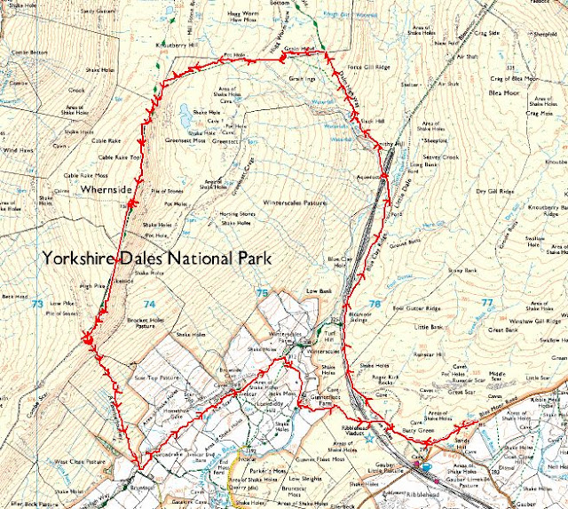
NORTH YORKSHIRE (DALES): Whernside (8 miles)


Saturday, 26th March 2022

After a “bit of a hiccup” getting to the parking spot I finally met up with Paul for a wander up Whernside. 


The weather was absolutely gorgeous – almost too warm and I’m soooo glad I didn’t take the big thick fleece jacket I was planning on wearing.  Absolutely no need for it whatsoever.  It really was t-shirt weather.


We trotted off down the road a little way before joining the main path, along with a million other people.


The task ahead:  


Getting a little nearer to Ribblehead Viaduct: 


Navigation definitely isn’t an issue on this walk.

We get to the iconic Blea Moor signal station/box: 


It could do with a bit of a spruce up and lick of paint.


It’s a fairly featureless landscape in some respects – vast moorland views although the skyline is dominated with views of Ingleborough and Pen-y-Ghent and it was a bit of a surprise to me to see how close they seem.


Hazy Ingleborough: 


I did take some more pics but the views were hazy and they didn’t turn out very well at all, but the views were better in real life. 


An unimaginatively named “waterfall” on Force Gill: 


To be honest, I could have got a better pic of this too but we were too busy yakking!


We reached a crossroads: 

By this point we were looking for a likely place for Snack Stop Number 1 and Paul suggested carrying on towards Deepdale to get away from the crowds a bit.  So that’s what we did.  The path gets noticeably rougher at this point but still easy enough underfoot.


We found a suitable tumbledown wall to perch on and stare at the even more impressive views of Ingleborough and PyG now that we were a bit higher up.  But again, the haze made the pics rubbish.


We bog-hopped along the (wrong side of the) fence, looking for a suitably bendy/saggy bit of wire fence to clamber over to re-join the main path. I was quite happy with this bog-trotting adventure, Paul, less so, I think


Another attempt at a pic of the views: 


I used the “wide” function on my phone’s camera and, well, yeh.  It flattens the two most prominent hill in view somewhat.


A little further along and we got a frog chorus. Or, as Paul called it frogpawn: 


The little dark lumps in the water are all frogs, all ribbeting away.  It was just like being in the Serangeti (or somewhere!). I took a little vid of it too, more for the frog chorus than anything (turn up the volume):


We’re heading onto the “nose” of Whernside now and I’m realising that, although I’ve been walking almost daily, doing yoga, tai chi and using the gym, there is nothing NOTHING that gets you hill fit other than walking up hills.  Something I’ve not had chance to do since November last year.  I stopped to admire the views.  A lot.  It’s not even a particularly steep gradient.  I was reassured by Paul that it gets dark around 6pm but not to worry, he’d brought a headtorch!


The tarn on Greensett Moss: 


With Ingleborough looking pretty impressive beyond.


After what seemed like ages (probably was) we reached the trig. I tapped the top and took this shot quickly before more people appeared:


There’s a squeeze-stile to get through coming the way we came and it’s not very forgiving!


There are also a couple of little shelters either side and I sat in one of them to tend to a blister that was making an appearance on my heel – thanks Paul for the Compeed – I’m now a convert and think these are a viable workaround for my shoe stitching issue.


We didn’t stop long here as there was lots of people drifting past. Including three blokes, one of whom was on his first ever hill walk – he looked a bit tired!  Paul offered to take a pic of the three of them at the trig and one of the guys clambered up and stood on the top of it.  Rather him than me!


But oh, the views from the top were gorgeous.  Although we were under cloud, the surrounding hills were dappled with sunlight and cloud shadows and it looked gorgeous.  The Howgills looking all lumpy and bumpy and inviting to the north.  Ingleborough and Pen-y-Ghent looking pretty imposing to the east.  The Lake District mountains were just visible through the haze to the west.  The vast flatness (in comparison) of the rest of England to the south and Morecambe Bay just visible in between.


We trotted off on the easy (at the moment) descent before taking a left turn down the hillside to join The Pennine Journey path.


Before we dropped too far down, we found some convenient rocks for Snack Stop Number 2.  Paul pointed out the path we were to follow back to the viaduct.  It still looked a long way away!


Fed and watered for a second time, we continued steeply down the hillside, made somewhat easier by the newly laid stone steps – a weird green colour and definitely not native.  I hope they weather a bit.


The gradient eased after we reached the gate and it was a pleasant meander through farmland where I saw lambsies:


My first of the year.  Awwwwwww


And so back to the viaduct again: 


An attempt at an arty-farty pic: 


Plaque: 


I had a brief rest here as my legs were sore now but it really wasn’t far back to the cars.


Back at the cars we checked the scores on the doors.  I was interested to know how my new mapping app had fared I got a splidge over 8 miles, Paul got a splidge over 9 miles. It felt like a splidge over 20 miles.


But whether it was 8 or 9 miles, it was a smashing walk and not bad going (for me) as the longest walk I’ve done this year so far.  Anyway, it’s given me restless legs and wanderlust again.


Cheers to Paul for organising.  A smashing day out in the hills and that's my final Y3P ticked off...

.... Now for the N3P (eeeeek). 


Thanks for reading 😊


NORTH YORKSHIRE (MOORS): Lastingham (6.7 miles)

 Sunday, 22nd August 2021


I met up with Ed in Lastingham up on the North York Moors for a spot of heathery overload before it was too late.


Someone had mentioned that the hardest part of navigating is heading the right way out of the car park.  After exploring every road out of Lastingham (to see what was up there of course) we finally took the steepest one past the pub.  Or was it the one over the beck?  Did we even cross a road over the beck? Was there a beck? Or maybe it was that other road.  Anyhow, eventually we got to the end of whatever road it was and burst out (okay, we walked through a gate) onto the open access moorland:


After a quick skeg at the walk instructions we strode confidently off, following a “clear track” across the increasingly heathery loveliness.  After a quick skeg at the map we strode confidently to the not very clear track we should have been on.  Well, we wanted to see what that scrap of paper pinned to a fence said about the arson/wildfires near the bathing pools anyway.


Mandatory sheep in heather pic:


The instructions said to cross Tranmire Beck and we dropped down quite steeply to do this.  Crossing the beck was easy enough and that part of the walk was the steepest and roughest of the whole walk.  Looking back from whence we came:


The instructions said something along the lines of keep ahead until you reach a track at Askew Rigg, then turn left:


Track successfully and uneventfully reached, we turned left.  It’s a very clear track isn’t it?  Not really difficult to accidentally not walk on it, is it?  I’m glad we were using our own unique blend of navigational skills rather than plotting the route on a GPS because, if we had, we’d have plotted the route following the RoW … and then we’d have been yomping across trackless heather because that was absolutely nowhere near this track.


There was lots of tumuli-usses dotted around.  Most looked like little heathery upturned pudding basins but this one was obviously a very important person.  Marked on the map as nothing more than “Pile of Stones” now.  At first, we were thinking the little heathery puddings weren’t very big for a person to be buried in but further reading says they mark a grave so there is someone buried under them – a kind of ancient headstone then, I guess. 


The instructions said “ignore path to left”.  Which we duly did, mainly because we never saw one to ignore in the first place.


We reached “Abrahams Hut” which appeared to be another pile of stones, and even then, that would be a fairly loose description.  So we might not have reached Abrahams Hut at all.  The map shows a gazillion paths, the instructions were basically saying keep left/take the left path.  Where this maze of paths was I do not know because, yep, you’ve guessed it, that very clear sandy track?  We were still on that with not a left turn in sight.


It started spit-spotting with rain and, looking at the big black cloud which seemed to be heading our way, we decided it was a waterproofs on moment.  Good job because it did start to rain properly, albeit briefly.


Although not part of the walk route Ed had, we were nearing Redmans Cross (remains of) and I felt an uncontrollable urge to heather hop and go and find it.  After a couple of false alarms, we found it:


There was a sort of cliff face(!) nearby so we sheltered in there and had Snack Stop number 1:


…before heading back along the faint soggy track back to that unmissable sandy track:


From here, Ana Cross comes into view:


At first, I was reluctant to take this pic because there were other people there but it gives a bit of scale to the size of the cross.  They hung around a while admiring the views and I think took a selfie or two before disappearing. 


Getting nearer:


There was no inscription or plaque with any info on.  Just a huge cross, in the middle of the moors:


This is the opposite view of one Ed took.  We took the pics at the same time, facing each other. In’t being invisible great!


The instructions said “take the path south”.  Umm.  The only track we could see was the one we’d come off.  You know, that massive, obvious sandy track.  And that wasn’t heading south.  Compass time.  After discovering which way was south, we heading in “generally that direction”.  And joined up fairly quickly with another obvious sandy track.  Who knows, it could have been “our” sandy track that curved round.  The moors can be very deceptive.  Anyhow, this was still heading in a generally south sort of direction so we thought we’d give it a shot. So far, both the map and the instructions had been next to useless!


But it was very easy walking on very gentle gradients and would probably make a good winter walk, although the drive down into Lastingham might be a bit hairy if it was icy.


Somewhere along this path we had Snack Stop Number 2:


We perched on a large square slab of stone.  Selfishly, I nabbed the direction with the best view whilst Ed, too scared to argue with me, sat facing a boring view.  The sun had come out by now and it was the nicest part of the day.  I’m so glad I got to see the heather in all it’s wonderful, purpleyfield glory


Looking across to Cropton Forest:


We sat here a while and discussed aches and pains, mainly prompted by Ed's impressive downward dog yoga pose to ease his back.  That set me off so I had to have a go and then I had to do a tree pose stood on the square stone, much to the amusement of a couple who were strolling past. 


More gentle downhill and we were soon, too soon, back at the gate:


There is a bench here and we sat here a while too which was a bad idea because we started talking about popping into the pub before the drive home.


So we did.  And sat in the beer garden a while too.  First time I’ve been in a pub since the Plague struck and it felt nice to do something normal.  The food looked and smelt delicious but we didn’t partake.


Walking back to the cars we spotted a few wells in the village:


What a smashing walk amongst oodles of heathery, purpleyfied loveliness.  Cheers Ed.


Oh, on my drive home, I passed a pub sign – unofficially renaming itself “The Vaccinated Arms” which made me chuckle.


Thanks for reading.